India Map

India Flag

Map of India

Discover India’s incredible diversity through its many states, languages, and cultures. Explore its famous rivers, historic monuments, growing cities, and strong economy in a clear and easy-to-understand way. This overview helps you see how India’s rich heritage and modern progress come together to shape one of the world’s most unique countries.

India Overview

  • Total Area 3,287,263 sq km
  • Total States/UTs 28 States, 8 Union Territories
  • Capital New Delhi
  • Official Languages Hindi, English (and others)
  • Largest State (Area) Rajasthan
  • Smallest State (Area) Goa

India Presentation

India Map With Details

Map of Indian States (Interactive)
India States Map for Pan/Zoom
Key Geographical Points
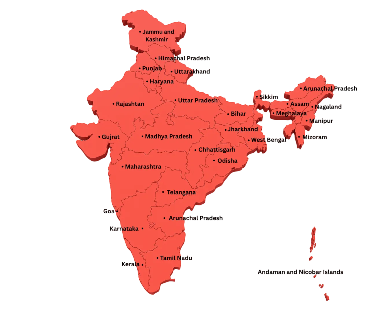
  • 28 States, 8 UTs: Diversity spanning North to South.
  • International Borders: Shares land borders with Pakistan, China, Nepal, Bhutan, Bangladesh, and Myanmar.
  • Coastlines: Bounded by the Bay of Bengal (East), Arabian Sea (West), and Indian Ocean (South).
  • Himalayas: Located in the North, one of the world's highest mountain ranges.
  • Ganga River: The country's most sacred and longest river, flowing through the Northern Plains.
  • Mountain Ranges: Himalayas in the North, Aravalli in the West, and Western Ghats in the South.
  • Rajasthan: Largest state by area, known for its deserts and forts.

India States List and Google Map

States List
Andaman & Nicobar Capital: Port Blair
Andhra Pradesh Capital: Amaravati
Arunachal Pradesh Capital: Itanagar
Assam Capital: Dispur
Bihar Capital: Patna
Chandigarh (UT) Capital: Chandigarh
Chhattisgarh Capital: Raipur
Dadra and Nagar Haveli and Daman and Diu Capital: Daman
Delhi (NCT) Capital: New Delhi
Goa Capital: Panaji
Gujarat Capital: Gandhinagar
Haryana Capital: Chandigarh
Himachal Pradesh Capital: Shimla
Jammu and Kashmir Capital: Srinagar (Summer), Jammu (Winter)
Jharkhand Capital: Ranchi
Karnataka Capital: Bengaluru
Kerala Capital: Thiruvananthapuram
Ladakh Capital: Leh
Lakshadweep Capital: Kavaratti
Madhya Pradesh Capital: Bhopal
Maharashtra Capital: Mumbai
Manipur Capital: Imphal
Meghalaya Capital: Shillong
Mizoram Capital: Aizawl
Nagaland Capital: Kohima
Odisha Capital: Bhubaneswar
Puducherry Capital: Puducherry
Punjab Capital: Chandigarh
Rajasthan Capital: Jaipur
Sikkim Capital: Gangtok
Tamil Nadu Capital: Chennai
Telangana Capital: Hyderabad
Tripura Capital: Agartala
Uttar Pradesh Capital: Lucknow
Uttarakhand Capital: Dehradun
West Bengal Capital: Kolkata
Google Map View (State)
Republic of India

India Rivers & Lakes List and Google Map

Rivers & Lakes List
Ashtamudi Lake Type: Lake
Banas Type: River
Beas Type: River
Betwa Type: River
Bhimtal Lake Type: Lake
Brahmaputra Type: River
Chambal Type: River
Chenab Type: River
Chilika Lake Type: Lake
Dal Lake Type: Lake
Gandak Type: River
Ganga Type: River
Ghaghra Type: River
Godavari Type: River
Hugli Type: River
Hussain Sagar Type: Lake
Indus Type: River
Jhelum Type: River
Kaveri Type: River
Kolleru Lake Type: Lake
Kosi Type: River
Krishna Type: River
Loktak Lake Type: Lake
Mahanadi Type: River
Naini Lake Type: Lake
Narmada Type: River
Pangong Lake Type: Lake
Pench Type: River
Periyar Type: River
Pulicat Lake Type: Lake
Ravi Type: River
Sambhar Lake Type: Lake
Satluj Type: River
Sharavati Type: River
Shipra Type: River
Shivsagar Lake Type: Lake
Son Type: River
Tapi Type: River
Teesta Type: River
Tso Moriri Lake Type: Lake
Tungabhadra Type: River
Upper Lake Type: Lake
Vembanad Lake Type: Lake
Wular Lake Type: Lake
Yamuna Type: River
Google Map View (River/Lake)
Major Rivers and Lakes of India

Top States Population and GSDP Graphs

Top Populous Indian States

1
Uttar Pradesh
241,066,878 People
2
Maharashtra
124,700,000 People
3
Bihar
128,500,000 People
4
West Bengal
99,600,000 People
5
Madhya Pradesh
85,000,000 People

Top Indian States by GSDP (Gross State Domestic Product)

1
Maharashtra
~ USD 470 Billion
2
Tamil Nadu
~ USD 320 Billion
3
Gujarat
~ USD 310 Billion
4
Uttar Pradesh
~ USD 290 Billion
5
Karnataka
~ USD 280 Billion

Frequently Asked Questions (FAQ)

What is the capital of India?

The capital of India is New Delhi, located within the National Capital Territory (NCT).

How many states and Union Territories are there in India?

India has 28 States and 8 Union Territories.

What are the major rivers of India?

Major rivers include the Ganga, Yamuna, Brahmaputra, Godavari, Krishna, and Kaveri.

What is the longest river in India?

The Ganga River is the longest river in India flowing through multiple states.

Which is the largest state in India by area?

Rajasthan is the largest state in India by area.

Which is the smallest state in India?

Goa is the smallest state in India by area.

Which Indian state has the highest population?

Uttar Pradesh has the highest population in India.

What is the national animal of India?

The national animal of India is the Bengal Tiger.

What is the national language of India?

India has no national language, though Hindi and English are widely used for official purposes.

Leave a Reply

Your email address will not be published. Required fields are marked *